


Idiomas
Páginas
Jurídico

!
Jalil Abad
62°23'20"E
62°23'20"E
62°23'0"E
62°23'0"E
62°22'40"E
62°22'40"E
62°22'20"E
62°22'20"E
62°22'0"E
62°22'0"E
62°21'40"E
62°21'40"E
62°21'20"E
62°21'20"E
62°21'0"E
62°21'0"E
62°20'40"E
62°20'40"E34°20'40"N
34°20'40"N
34°20'20"N
34°20'20"N
34°20'0"N
34°20'0"N
34°19'40"N
34°19'40"N
34°19'20"N
34°19'20"N
34°19'0"N
34°19'0"N
440000
440000
440500
440500
441000
441000
441500
441500
442000
442000
442500
442500
443000
443000
443500
443500
3797
500
3797
500
3798
000
3798
000
3798
500
3798
500
3799
000
3799
000
3799
500
3799
500
3800
000
3800
000
3800
500
3800
500
GL IDE number: N/A
!(
HeratHa rirud
J a lil Aba d
0201
03 04^
China
India
Ira n Pa kista n
Ta jikista nT urkmenista n
Uzbekista n
AfghanistanKa bul
Cartographic Information
1:6500
±Grid: W GS 1984 UT M Z one 41N ma p coordina te system
Full color IS O A1, low resolution (100 dpi)
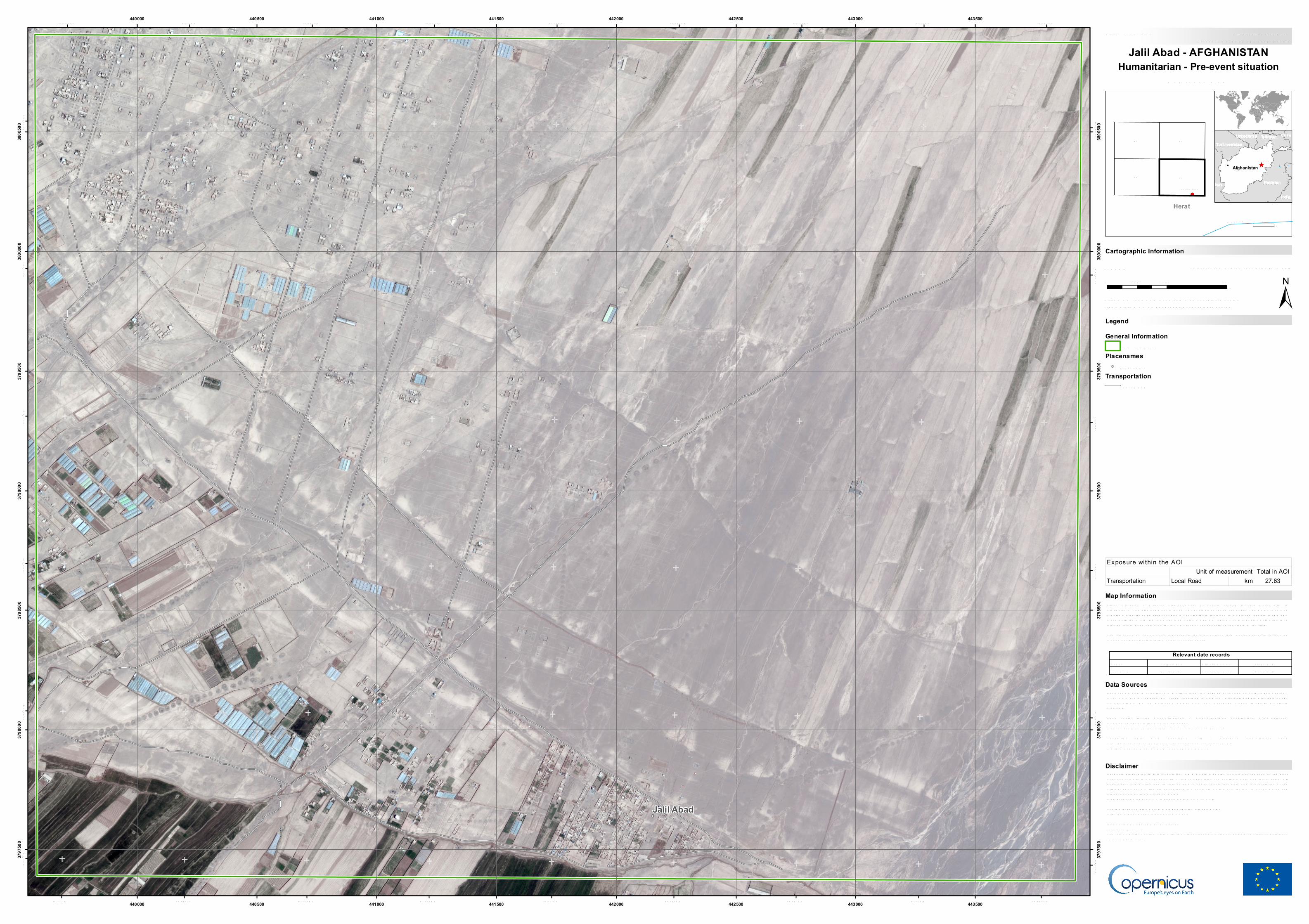
S ince mid-June a ma ssive displa cements of people sta rted towa rds Hera t City inAfgha nista n. T he displa cement is involving severa l thousa nds of people. T he ECHO’s surveyreports a high-level emergency, a nd a considera ble increa se in displa ced people tha t ma dema ke-shift tents, sta ying in 40 degrees Celsius. T he a im of the R a pid Ma pping a ctiva tion is toprovide informa tion a nd monitor the emergency for opera tiona l a na lysis in the field.T he present ma p shows ba sic topogra phic fea tures derived from public da ta sets, refined bymea ns of visua l interpreta tion of pre-event ima gery.
Products ela bora ted in this Copernicus EMS R a pid Ma pping a ctivity a re rea lized to the bestof our a bility, within a very short time fra me, optimising the a va ila ble da ta a nd informa tion. Allgeogra phic informa tion ha s limita tions due to sca le, resolution, da te a nd interpreta tion of theorigina l sources. No lia bility concerning the contents or the use thereof is a ssumed by theproducer a nd by the Europea n Union.Ma p produced by ITHACA relea sed by e-GEOS (ODO).For the la test version of this ma p a nd rela ted products visithttp://emergency.copernicus.eu/EMS R 296jrc-ems-ra pidma [email protected] .eu© Europea n UnionFor full Copyright notice visit http://emergency.copernicus.eu/ma pping/ems/cite-copernicus-ems-ma pping-porta l
Legend
T ick ma rks: W GS 84 geogra phica l coordina te system
Product N.: 04J ALIL ABAD, v1, EnglishActiva tion ID: EMS R 296
Pre-event ima ge: W orldView-3 © Digita l Globe, Inc. (2018), (a cquired on 27/04/2018 a t 07:14UTC, GS D 0.3 m, a pprox. 0% cloud covera ge in AoI, 2.2° off-na dir a ngle), provided underCOPER NICUS by the Europea n Union, ES A a nd Europea n S pa ce Ima ging, a ll rightsreserved.Ba se vector la yers: OpenS treetMa p © OpenS treetMa p contributors, W ikima pia .org,GeoNa mes 2015, refined by the producer.Inset ma ps: J R C 2013, Na tura l Ea rth 2012, GeoNa mes 2013.Popula tion da ta : GHS Popula tion Grid © Europea n Commission, 2015http://da ta .europa .eu/89h/jrc-ghsl-ghs_ pop_ gpw4_ globe_ r2015a .Digita l Eleva tion Model: S R T M (30m) (NAS A/US GS )
0 0,25 0,50,125km
Jalil Abad - AFGHANISTANHumanitarian - Pre-event situation
Map Information
R eference Ma p
Relevant date recordsEvent S itua tion a s of15/06/2018 27/04/2018Activa tion Ma p production13/07/2018 14/07/2018
Disclaimer
Data Sources
2km
General InformationArea of Interest
Placenames! Pla cena me
TransportationLoca l R oa d
Total in AOITransportation Local Road km 27.63
Exposure within the AOIUnit of measurement
Top Related