


Idiomas
Páginas
Jurídico


Tu o l u mn e Co un tyM u l t i - J u ri s d i ct i o nal
Ha za rd M i t i g a t ion Pl a n 2 0 1 8
An n ex U: L a k e D o n P e d r o
C o m m u n i t y S e r v i c e s Di s t ri ct

Tuol umne Co unty Mul ti -Juris dictio na l Ha za rd Mitiga tio n Pl a n
ANNE X V: LAKE DON PEDRO COMMUNITY SERVICES DIS TRICT
I. JURISDICTION PROFILE ....................................................................................................... 4
II. PLANNING PROCESS ...............................................................................................................5
A. DMA 2000 Requirements .............................................................................................................5
B. Plan Develop ment and Public Input Process .......................................................................... 5
C. Ju risdiction Specific Planning and Approval Process ............................................................ 6
III. RIS K ASSESSMENT ................................................................................................................. 7
A. DMA 2000 Requirements ............................................................................................................ 7
B. Jurisdiction Specific Risks ........................................................................................................... 7
C. Ju risdiction Specific Hazard Event History .............................................................................. 8
D. Ju risdiction Specific Hazard Ranking ..................................................................................... 10
IV. VULNERABILITY ASSESSMENT ........................................................................................ 11.
A. Overview ...................................................................................................................................... 11
B. DMA 2000 Requirements .......................................................................................................... 12
C. Critical Facilities and Infrastructure ....................................................................................... 12
D. Ju risdictional Assets at Risk to Applicable Hazards ............................................................. 13
E. Methodology Used ...................................................................................................................... 13
F. Loss Estimations .......................................................................................................................... 13
G. Develop ment Trend Analysis ..................................................................................................... 14
V. CAPABILITY ASS ESSMENT .................................................................................................... 14
A. L egal and Regulatory ................................................................................................................. 14
B. Ad ministrative and Technical ................................................................................................... 14
C. Finan cial ...................................................................................................................................... 15
D. Physical Assets ............................................................................................................................ 15
E. Political Will of Community ...................................................................................................... 15
VI. MITIGATION ST RATEGY ...................................................................................................... 15
A. DMA 2000 Requirements .......................................................................................................... 15
B. 20013 Mitigation Action Progress Report ............................................................................... 15
C. Goals, Objectives and Mitigation Actions 2018 ...................................................................... 17
D. How Mitigation Goals Address Buildings and Infrastructure ............................................. 25
VII. MITIGATION ACTION IMPLE MENTATION ................................................................... 29
A. DMA 2000 Requirements .......................................................................................................... 29
B. Prioritization of Mitigation Actions ......................................................................................... 29

Tuol umne Co unty Mul ti -Juris dictio na l Ha za rd Mitiga tio n Pl a n
C. Action Plan ................................................................................................................................. 30
D. Implemen tation Through Existing Plans and Programs ..................................................... 35
E. Con tinued Public Involvement ................................................................................................. 35
F. Plan Maintenance, Updating and Evaluatin g ....................................................................... 35
ACRONYMS ...................................................................................................................................... 37
Plan Approval Docum entat i on - Resol ut i on No. 2017-xx..........................................................38
Tuol umne Co unty Mul ti -Juris dictio na l Ha za rd Mitiga tio n Pl a n
4
LAKE DON PEDRO COMMUNITY SERVICES DIST RICT
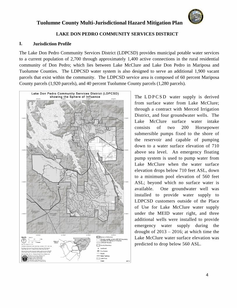
I. Ju risd i ction Prof ile
The Lake Don Pedro Community Services District (LDPCSD) provides municipal potable water services
to a current population of 2,700 through approximately 1,400 active connections in the rural residential
community of Don Pedro; which lies between Lake McClure and Lake Don Pedro in Mariposa and
Tuolumne Counties. The LDPCSD water system is also designed to serve an additional 1,900 vacant
parcels that exist within the community. The LDPCSD service area is composed of 60 percent Mariposa
County parcels (1,920 parcels), and 40 percent Tuolumne County parcels (1,280 parcels).
The L D P C S D w a t e r s u p p l y i s d e r i v e d
f r o m s u r f a c e w a t e r f r o m L a k e M c C l u r e ;
t h r o u g h a c o n t r a c t w i t h M e r c e d I r r i g a t i o n
D i s t r i c t , a n d f o u r g r o u n d w a t e r w e l l s . T h e
L a k e M c C l u r e s u r f a c e w a t e r i n t a k e
c o n s i s t s o f t w o 2 0 0 H o r s e p o w e r
s u b m e r s i b l e p u m p s f i x e d t o t h e s h o r e o f
t h e r e s e r v o i r a n d c a p a b l e o f p u m p i n g
d o w n t o a w a t e r s u r f a c e e l e v a t i o n o f 7 1 0
a b o v e s e a l e v e l . A n e m e r g e n c y f l o a t i n g
p u m p s y s t e m i s u s e d t o p u m p w a t e r f r o m
L a k e M c C l u r e w h e n t h e w a t e r s u r f a c e
e l e v a t i o n d r o p s b e l o w 7 1 0 f e e t A S L , d o w n
t o a m i n i m u m p o o l e l e v a t i o n o f 5 6 0 f e e t
A S L ; b e y o n d w h i c h n o s u r f a c e w a t e r i s
a v a i l a b l e . O n e g r o u n d w a t e r w e l l w a s
i n s t a l l e d t o p r o v i d e w a t e r s u p p l y t o
L D P C S D c u s t o m e r s o u t s i d e o f t h e P l a c e
o f U s e f o r L a k e M c C l u r e w a t e r s u p p l y
u n d e r t h e M E I D w a t e r r i g h t , a n d t h r e e
a d d i t i o n a l w e l l s w e r e i n s t a l l e d t o p r o v i d e
e m e r g e n c y w a t e r s u p p l y d u r i n g t h e
d r o u g h t o f 2 0 1 3 – 2 0 1 6 ; a t w h i c h t i m e t h e
L a k e M c C l u r e w a t e r s u r f a c e e l e v a t i o n w a s
p r e d i c t e d t o d r o p b e l o w 5 6 0 A S L .

Tuol umne Co unty Mul ti -Juris dictio na l Ha za rd Mitiga tio n Pl a n
5
T h e e s t i m a t e d y i e l d o f t h e f o u r w e l l s c o m b i n e d i s a p p r o x i m a t e l y 3 5 5 g a l l o n s p e r m i n u t e , a n d t h e p e a k
c u s t o m e r w a t e r d e m a n d , u n d e r m a n d a t o r y 5 0 % w a t e r r e s t r i c t i o n s , w a s a p p r o x i m a t e l y 4 6 4 g a l l o n s p e r
m i n u t e i n J u l y 2 0 1 5 .
T h e L D P C S D w a t e r t r e a t m e n t p l a n t i s a c o n v e n t i o n a l f i l t r a t i o n s y s t e m s u r f a c e w a t e r p l a n t , a n d i t s
w a t e r d i s t r i b u t i o n s y s t e m c o n s i s t s o f 7 t r e a t e d w a t e r s t o r a g e t a n k s , 1 r a w w a t e r s t o r a g e t a n k , s i x
b o o s t e r p u m p s i t e s , t h r e e h y d r o p n e u m a t i c s s y s t e m s , e l e v e n p r e s s u r e r e g u l a t i n g s t a t i o n s , 8 2 1 m a i n
i s o l a t i o n v a l v e s a n d 4 8 5 f i r e h y d r a n t s . W a t e r m a i n s r a n g e i n s i z e f r o m 2 - i n c h P V C t o 1 2 - inch
a s b e s t o s c e m e n t .
II. PL ANNI NG PROCE S S
A. DMA 2000 Req u ire men ts
DMA Req u ire men ts An open public involvement process is essential to the development of§201.6(b ) an d an eff ective plan. In orde r to develop a mor e com prehensive approa ch§201.6(c)(1 ): to reducin g the e ffe cts of natural disasters, the pla nning pro cess
shall include:(1) An opportunit y for th e public to comment on the plan durin g the draftin g sta ge and p rior t o plan approval;(2) An opportunit y for n e ighborin g communities, local and r e gional agencies involved in haz ard mitigation a ctivities, and a gen cies that have the authorit y to r e gulate development, as well as businesses, acad emia and other privat e and non -profit interests to be inv olved in the planning process; and(3) R eview an d incorpor ation, if appropriate, o f e x isting plans, studies, reports, and te chnical inf ormation.The plan shall document the planning pro cess use d to develop the plan, including how it was pr e pared, who was involved in the process,and how the public was involved.
B . Plan Dev elop men t an d Pu b lic In p u t Proc ess/Cou n tyw id e E lemen ts
Volume 1 is the master planning document whi ch contains all elements applicable to the C ount y of
Tuolumne and each of the 22 individual jurisdictions. Plan development commenced with a review and
revision of the updated 2013 Haz ard Mitigation P lan. Each of the participating jurisdictions
participated full y in the mitigation plan update.
Tuol umne Co unty Mul ti -Juris dictio na l Ha za rd Mitiga tio n Pl a n
6
A news r elease was d eve loped and issued and inf ormative letters w ere s en t out to communit y grou ps
and neighborin g ju risdictions inviting public partici pation. A H az ard Mitigation P lanning Group w as
co nstructed with repr esent atives from all involved jurisdictions and communit y stakeholders. P lannin g
group meetin gs we re h eld which ex plained the pro c ess that was goin g to b e t aken to construct the ne w
plan , review ed haz ards o f co ncern and haz ard rankin gs, an d ex plained the ris ks and vulnerabilit y to the
communities’ people, buildings and infrastru cture. Mitigation goals, objecti ves and actions were
discussed a nd reviewed thorou ghl y with all planning group members until concurren ce was reach ed. A
capabilit y a ssessment and action plan were dev eloped to e nsure mitigation actions were realistic and
attainabl e an d to assign fundin g sour c es and responsibilit y fo r each propos ed a ctivit y.
After the MJ HMP Planning Group Membe rs, their respective jurisdictions, and Tuolumne C ount y
Office of Emer genc y S ervic es were all satisfied with the newl y updated dra f t plan and its mitigation
goal, objectives and actions, a noticed public h earin g occurr ed at the C ount y Emer genc y Ope ration’s
C enter. This meeting was widel y a dvertised both locall y and in nei ghbo ring cou nties to provide an
oppo rtunit y for the gener al public, borderin g communities and re gional a gen cies i nvolved in haz ard
mitigation activities to participate i n the planning pro cess. Notice of the public he a ring w as posted,
two we eks in advanc e, on the C ount y website, communit y bull etin boards and throu gh a press
r eleas e. Notific ation letters wer e sent to Offic e of Eme r genc y S ervices mana gers in all nei ghbo ring
C ounties. S ev eral weeks prior to the he arin g, the newl y construct ed P lan was posted on the C ount y
w ebsite to en able the public and stakeholders ample time to read and evaluat e it. A P ower P oint
presentation was develope d that provided a detailed ex planation of the risks and vu lnerabilities the
communit y fa ced.
The mitigation goals, objectives and a ctions were ex plained in detail as were the resou rces th at would be
used to help mitigate the se haz ards. In addition, the gener al public had a n opportunit y to ask
que stions and comment on the pro posed plan and each o f t he annex es as the y move d through the
approv al process for Tuolumne C ount y an d each of the participati ng jurisdictions. All comments were
review ed with the stakeholder gro up and incorpor ated into the plan as approp riate.
C. Ju risd iction Sp ecif ic Plan n in g an d App roval Process
The d i s t r i c t m a n a g e r f o r L a k e D o n P e d r o C S D participated in the Haz ard Mitigation P lanning Group.
H e revie wed the findin gs with special attention bein g paid to the issues of w ildland fire and
ex treme we ather prep ar edness. The district manager’s input was inc orporated into both draft and
final documents, an d reviewed b y District st aff. A staff r eport was p rep are d and m ade available t o the
gener al public for comment a nd w as ev e ntuall y forwa rded to the Lake Don Pedro CSD Board of
Directors. A public meeting was held within the jurisdiction; input was rec eived f rom the gener al public
and incorpor ated into the final approved a genc y sp ecific plan.
Tuol umne Co unty Mul ti -Juris dictio na l Ha za rd Mitiga tio n Pl a n
7
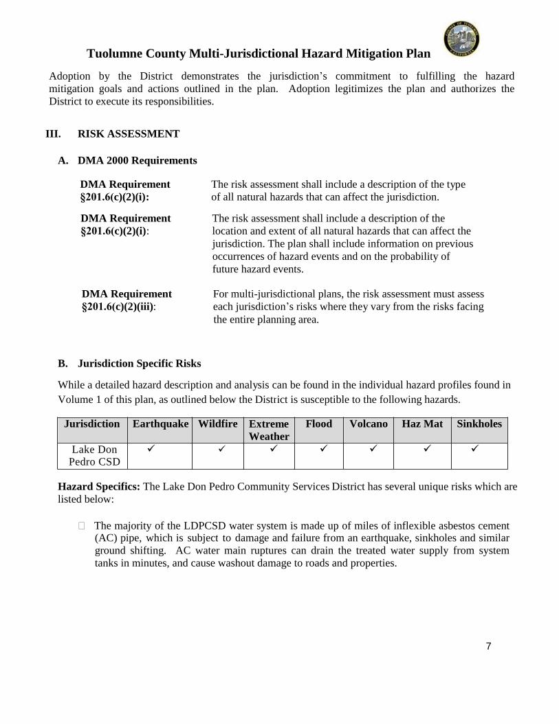
Adoption b y th e District demonstrates the jurisdiction’s commitment to f ulfilling the haz ardmitigation goals and actions outlined in the plan. Adoption legitimiz es the plan and a uthoriz es theDistrict to ex ecute its responsibilities.
III. RIS K AS S ESS ME NT
A. DMA 2000 Req ui remen ts
DMA Req ui remen t The risk assessment sh all include a descript ion of the t yp e§201.6(c)(2 )(i) : of all natural haz ards t h at can affect t he jurisdi cti on.
DMA Req ui remen t The risk assessment sh all include a descript ion of the§201.6(c)(2 )(i) : locati on and ex tent of all natural haz ards that can affect t he
jurisdi cti on. The plan shall in clude informati on on p reviousoccurrences o f haz ard events and on the probabil ity of future haz ard events.
DMA Req ui remen t For mul ti -jurisdi ction al plans, the risk assessm ent must assess§201.6(c)(2 )(iii): each jurisdi cti on’s risks where the y v ar y from t he risks facin g
the enti re plannin g area.
B . Ju risd i ction Sp ecif ic Risk s
W hil e a detailed haz ard des cript ion and an al ysis ca n be found in t he indi vidual haz ard profiles foun d in
Volum e 1 of thi s pl an, as outl in ed below the Dist rict i s sus cepti ble to t he following haz ards.
Ju risd i ction E arth qu ak e Wil df ire E xtre meWeath er
Flood Volcan o Haz Mat S in kh ol es
L a k e D o n P e d r o C S D
Hazard S p ecif ics: The Lake Don Pedro Community Services Dist ri ct has several uni que risks which are li st ed below:
The majority of the LDPCSD water system is made up of miles of inflex ible asbestos cement(AC) pipe, which is subj ect to d amage and failure from an earthquake, sinkholes and s imilarground shi ftin g. AC water main ruptures can drain the treated water supply from systemtanks in minutes, and cause washout damage to roads and properties.
Tuol umne Co unty Mul ti -Juris dictio na l Ha za rd Mitiga tio n Pl a n
8
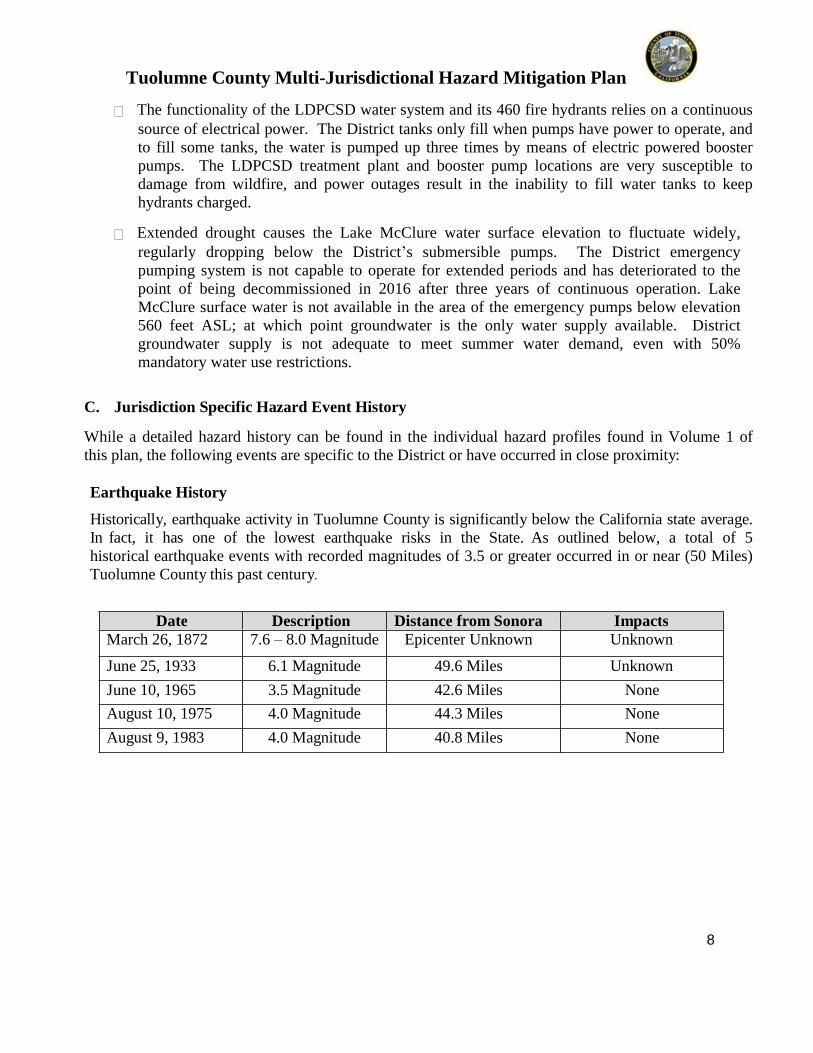
The functionality of the LDPCSD water system and its 460 fire hydrants relies on a continuoussource of electrical power. The District tanks only fill when pumps have power to operate, andto fill some tanks, the water is pumped up three times by means of electric powered boosterpumps. The LDPCSD treatment plant and booster pump locations are very susceptible todamage from wildfire, and power outages result in the inability to fill water tanks to keephydrants charged.
E x t e n d e d d r o u g h t c a u s e s t h e L a k e M c C l u r e w a t e r s u r f a c e e l e v a t i o n t o f l u c t u a t e w i d e l y , r e g u l a r l y d r o p p i n g b e l o w t h e D i s t r i c t ’ s s u b m e r s i b l e p u m p s . T h e D i s t r i c t e m e r g e n c y p u m p i n g s y s t e m i s n o t c a p a b l e t o o p e r a t e f o r e x t e n d e d p e r i o d s a n d h a s d e t e r i o r a t e d t o t h e p o i n t o f b e i n g d e c o m m i s s i o n e d i n 2 0 1 6 a f t e r t h r e e y e a r s o f c o n t i n u o u s o p e r a t i o n . L a k e M c C l u r e s u r f a c e w a t e r i s n o t a v a i l a b l e i n t h e a r e a o f t h e e m e r g e n c y p u m p s b e l o w e l e v a t i o n 5 6 0 f e e t A S L ; a t w h i c h p o i n t g r o u n d w a t e r i s t h e o n l y w a t e r s u p p l y a v a i l a b l e . D i s t r i c t g r o u n d w a t e r s u p p l y i s n o t a d e q u a t e t o m e e t s u m m e r w a t e r d e m a n d , e v e n w i t h 5 0 % m a n d a t o r y w a t e r u s e r e s t r i c t i o n s .
C. Ju risd i ction Sp ecif ic H azard E ven t His tory
W hil e a detailed haz ard hist o r y can be found in t he indi vidu al haz ard profiles found in Volum e 1 ofthi s pl an, the foll owing events are specific to t he Dist rict or have occurred in cl ose pro x imit y:
E arth qu ak e History
Historicall y, earthquake activit y in Tuolumne Count y is significantl y b elow t he Califo rnia state avera ge.In fact, it has one of the lowest earthquak e risks in the State. As outlined below, a tot al of 5hist orical earthquak e events with recorded magnit udes of 3 .5 or greater occur red in or near (50 Mil es)Tuolumne Count y thi s past centur y.
Date Descrip tion Distan ce f ro m S on ora I mp actsMarch 26, 1872 7.6 – 8.0 Magnit ude Epicenter Unkno wn Unknown
J une 25, 1933 6.1 Magnit ude 49.6 Mil es Unknown
J une 10, 1965 3.5 Magnit ude 42.6 Miles None
August 10, 1975 4.0 Magnit ude 44.3 Mil es None
August 9, 1983 4.0 Magnit ude 40.8 Mil es None

Tuol umne Co unty Mul ti -Juris dictio na l Ha za rd Mitiga tio n Pl a n
9
E xtre me W eath e r History
Date Descrip tion I mp acts1 9 8 9 - 1 9 9 2 Severe localized drought Near loss of surface water supply
2012 - 2016 Severe drought Loss of surface water supply due to regulatory restrictions
Flood Hi s tory
DAT E E VE NT DE T AILSW int er of1887
The earliest record rainf all amount found in The Union Demo crat indi catesthat 67 i n ches of rain fell. No dam ages were not e d.
Decemb erof 1964
The Coun t y Bo ard of S uperviso rs declares a state of em ergen c y bas ed onlocaliz ed floodi ng wit hin the Coun t y.
W int er of1969
A series of cold sto rms dropped 8 inches of snow on the C it y o f S onora,elevati on 1800 feet. The snow sta ye d on the grou nd for a full week as a c oldfront mov ed in behind the last sto rm. The Count y came to a standstil l as thelimited numbers of snow plows were unable to keep the roads open. Floodi ngwas rep o rted as snow melted.
Febru ar yof 1986
Earl y s eason sto rms com pletel y s aturated th e soil s. A fast movin g rain sto r min Feb ruar y caused S onora C reek to overbank floodi ng the Mother Lo deFair grounds.
March of1995
The Gov ernor of C alifo r nia request fed eral assi st ance after the Count y Bo ardof S up erviso rs declares a state of emer gen c y b ased on lo caliz ed floodingwit hin t he Count y.
April of2006
On Ap ril 11 th e Board of S up erviso rs passed an Emergen c y R esolut ionproclai mi ng the ex ist ence o f a local eme r genc y du e to a s eries of wint er sto rms that had “caused condit ions of ex treme peril to the safet y o f p erso nsand propert y b ecause of localiz ed floodi ng in the Count y o f Tuolum ne”. InS onora proper, S onora High was flooded as S onora C reek ov erbank ed.
March2011
W ith the season rain fall accumulations of nearl y 60 inches, a lat e season storm,accomp anied b y ex tremel y hi gh winds, caused n earl y $750,000 in dama gesacross the count y. Da mages to the flume syst ems, roadw a ys, ele ctricaldistribution s ystem and tree dam age to numero us residen ces resulted in arequ est for a Fede ral Disa ster De claration.

Tuol umne Co unty Mul ti -Juris dictio na l Ha za rd Mitiga tio n Pl a n
10
L o c a l L a k e D o n P e d r o C o m m u n i t y D r o u g h t History
Date EVENT DETAILS1 9 8 9 - 1 9 9 2 Precipitation was far below normal in the region during the winters of 1989,
1990, 1991 and 1992, causing the Lake McClure water level to drop 120 feet below LDPCSD pumps. Emergency floating pumps were launched and operatedin 1991 and 1992 to provide community water supply
2013 - 2016 Beginning in the winter of 2012/13, precipitation was far below normal causing Lake McClure water level to drop 130 feet below LDPCSD pumps, resulting in the launch of the emergency floating pumps in October 2013. By January 2015, predictions placed the lake water level below the emergency pumps within 60 days. On January 1, 2016, the state prohibited further pumping from Lake McClure creating a surface water outage and reliance on minimal local groundwater
Volcan ic HistoryThere is no histor y o f vo lcanic acti vit y in r ecord e d hist o r y. Th e prox imity to vol canic acti ve area s does present a remot e threat of ash fall and the associated respi rator y illnesses.
Hazard ou s Material sWhile there is not a significant history of hazardous material spills or releases in the immediate area the location of Highway 49 parallel to and above the Merced River canyon as it enters Lake McClure make the threat of hazardous materials spills in Lake McClure near the LDPCSD water intake a distinct possibility.
S in kh ol esThere is a poo rl y docum ented hist or y of small sinkholes and subsi den ce as a result of mi ni n g acti vit y and the occurrence below gro und of carbon ated ro ck formati ons. There are no record ed ev ents of significance.
WildfireIn 2017, two wildfires occurred within the District boundaries causing minor localized structure damage, but threatening the entire community. Water supply from the LDPCSD system was used to assist in controlling these fires quickly. In addition, major wildfires occurred in 2017 adjacent to the District boundaries (Detweiler Fire), causing major losses of structures, power outages, and threatening the water supply and pumping facilities of the District.
Date Descrip tion Imp ac tsAugust, 1987 S tanislaus C omplex 6 major fires burn 145,95 0
acres, 28 stru ctures, and 1 life was lost.

Tuol umne Co unty Mul ti -Juris dictio na l Ha za rd Mitiga tio n Pl a n
11
S eptember, 2004 Tuolumne Fire 750 acres bu rned and 1firefi ghter fatalit y.
August 2013 R i m F i r e 257,314 acres burned112 Structures destroyed
October 2017 D e t w i l e r F i r e 81,826 acres burned63 residences, 67 minor structures and 1 commercial structure destroyed
D. Ju risd i ction Sp ecif ic H azard Ran kin g
Given the past histo r y, t he current condit ions, and the overall life and p ropert y th reat to the L a k e D o n P e d r o C o m m u n i t y S e r v i c e s Dist rict the P lanning Comm it t ee has deemed the prob abil i t y a nd sev erit yo f e ach haz ard as foll ows:
Lake DonPedro CSD
W i l d f i r e E arth qu ak e E xtre meWeath er
Flood Volcan o HazMat
S in kh ol es
P robabil it y L H M L M LS everit y H H M L L L
L = Lo w, M = M ed i u m, H = H i gh
III. VUL NE RABIL ITY ASS ES S ME NT
A. Overview
The vulnerabil i t y assess ment is a summ ar y of th e haz ard’s impact to the Dist rict ’s vulnerablestructures. Dist rict assets and developm ent trends will be identi fied and assessed with respect tothe developed haz ard profiles to ascertain the potenti al amount of dam age that could ensue from eachidenti fied haz ard. This secti on will include: 1) A descript ion of the criti cal buil din gs andinfrastructure wit hin the stu d y areas includi n g future b uil ding and land use decisi ons. 2) A generald e script ion of the ex tent of each haz ard’s impacts to these vuln erable structures, 3) An esti m ate of thepotenti al doll ar loss es to vulnerable st ructures.

Tuol umne Co unty Mul ti -Juris dictio na l Ha za rd Mitiga tio n Pl a n
12
B . DMA 2000 Req ui remen ts
DMA Req ui remen t The risk assessment sh all include a descript ion of the jurisdi cti on’s§201.6(c)(2 )(ii): vulnerabil i t y to t he haz ar ds described in paragrap h (c)(2 )(i) of this
secti on. This d escript ion sh all in clude an overall summ ar y o f e achhaz ard and it s im pact on the comm uni t y.
DMA Req ui remen t The plan should describ e vulnerabil i t y in t erms of the t ypes and§201.6(c)(2 )(ii)(A): numbers of ex ist ing and future buil din gs, in frastructure, and critical
facilities located in t he identi fied haz ard areas.
DMA Req ui remen t [ The plan should describe vulnerabil i t y in t erms of an] esti m ate of the§201.6(c)(2 )(ii)(B ): potenti al dol l ar losses to vuln erable structures id enti fied in paragraph
(c)(2 )(i)(A) of thi s s ection and a descript ion of the methodol og y used to prepare the esti m ate .
DMA Req ui remen t [ The plan should describe vulnerabil i t y in t erms o f] providi ng a§201.6(c)(2 )(ii)(C): gen eral d escript ion of land uses and developm ent trends wit hin t he
comm uni t y so that m it igati on opti ons can be con s idered in future land decisi ons.
DMA Req ui remen t For mul ti -jurisdi ction al plans, the risk assessment must assess each§201.6(c)(2 )(iii): jurisdi cti on’s risks where the y v ar y from t he risks facin g the enti re
planning area.
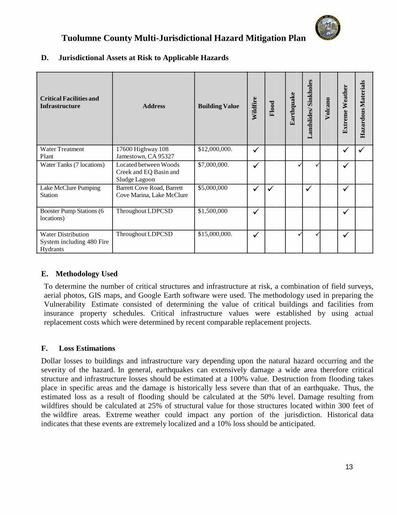
C. Critical Facilities an d In f rastru ctu re
C ritical facil iti es and infrast ructure are those s yst e ms wit hin each communit y whose in capacit y o r destructi on would have a debil it ati ng effect on t he comm uni t y’s abil i t y to r ecover subs equent t o a major dis aster. The followin g criti cal facili t y and infrastructure are cat ego riz ed as foll ows:
1. E mergen cy S ervices fo r the healt h and welfare of the whole populati on (e. g., hospit als, poli ce, fire stati ons, emergen c y operati ons cent ers, ev acuati on shelters, schools ).
2. L if elin e Utility S ys tems such as pot able water, wastewater, oil , natural gas , electric power and comm uni cati ons s ystems .
3. T ran sp ortation S ystems includi ng railwa ys, h i gh wa ys, wat erwa ys, airwa ys and cit y streets t o enable effecti ve mov eme nt of services, goods and people.
4. Hi gh Poten tial Loss Fa cilities such as power plants, d ams and levees.
Tuol umne Co unty Mul ti -Juris dictio na l Ha za rd Mitiga tio n Pl a n
13
D. Ju risd i ction al Assets at Risk to Ap p li cab le Hazard s
Cr it ica l F a cilities a ndInf ra st ruct ure Address B uildin g Va lue
Wil
df i
re
F lo
o d
Ea
rt h
qu
a k
e
La n
dsl
ides
/ Sin
kh
o le
s
Vo l
ca n
o
Ex t
re m
e W
ea t h
er
H a
za rd
o u
s M
a t e
r ia
ls
W a t e r T r ea tme ntP lant
1 7 6 00 H i g h way 1 0 8 J a me sto wn, C A 9 5 3 2 7
$ 1 2 , 0 0 0, 0 00 .
Water Tanks (7 locations) Lo ca ted b et wee n W o o d sCr ee k a nd E Q B asi n andSlud ge La go o n
$ 7 , 0 00 , 00 0 .
Lake McClure Pumping Station
Barrett Cove Road, Barrett Cove Marina, Lake McClure
$ 5 , 0 0 0 , 0 0 0
Booster Pump Stations (6 locations)
T hr o ugho u t L D P C S D $ 1 , 5 0 0 , 0 0 0
Water Distribution System including 480 FireHydrants
T hr o ugho u t L D P C S D $ 1 5 , 00 0 ,0 0 0 .
E . Meth od ology Used
To determine the numbe r of critical stru ctures and infrastru cture at risk, a combi n ati on of field surve ys,aerial photos, G IS maps, and Goo gle Earth so ftware wer e used. The m ethodol og y used in p reparin g theVulnerabil it y Esti m ate consist ed of determi ni ng the valu e of critical buil din gs and facilities frominsu rance propert y sch edul es. C ritical infrastructure values were es tabli sh ed b y usi n g a c tualreplacement costs which were d etermined b y re c e nt comp arable replaceme nt proj ects.
F. Loss E s timation s
Doll ar loss es to buil din gs and infrastructure var y depending upon the natural h az ard occurrin g an d thes everit y o f th e haz ard. In gen eral, earthquak es c an ex tensivel y dam a ge a wide area therefor e cr iticalst ructure and infrastructu re loss es should b e esti m ated at a 100% value. D estructi on from flooding takespl ace in specific areas and the damage is hist oricall y less sever e than that of an earthquake. Thus, theesti m ated loss as a result of floodi n g should be cal culated at the 50% l evel. Dam age result in g fromwildfires should be calc ulated at 25% of structural value for those structures located wit hin 300 feet ofthe wildfire areas. Ex treme weathe r could im pact an y po rti on of th e jurisdi cti on. Hist orical dataindi cates th at t hese ev ents are ex tremel y localiz ed and a 10% loss should be anti cip ated.

Tuol umne Co unty Mul ti -Juris dictio na l Ha za rd Mitiga tio n Pl a n
14
G. Develop men t T ren d An alysi s
W hil e the populati on of Tuolum ne Count y is not ex pected to grow significantly in th e n ex t five ye ars,there are Land Use poli cies an d elements wit hin t he Count y Gen eral P l an to help assure ord erl ydev elopm ent when it does occur.
In addit ion, the Lo cal Agen c y Formati on Comm issi on ( LAFC O) o f Tuolu mne Coun t y is tasked with themi ssi on to provide an orderl y patt ern of gro wth that reconciles the varied needs of the Count y. O ne ofthe fundamental principles of LA FC O is to en sure the establi shm ent of an appropriat e and logicalmuni cipal gov ernment stru cture for the dist ribut ion of efficient ad app rop riate publi c services. LAFCOLand Use Objectives in cl ud e:
The dis couragement of u rban sprawl
P reservati on of the ph ysi cal and economi c int egrit y of a gricult ural l ands
P reservati on of op en space wit hin u rban dev elopment patterns
Orderl y fo rmati on and de velopm ent of agen cies b y shapin g local a gen c y b o undaries
The mi nim iz ati on of agencies providi ng s ervices to a giv en area
Utiliz ation of S pheres of In fluen ce to guid e futu re developm ent of agen c y b oundaries
IV. CAPABIL IT Y AS S ES SME NT
The foll owing resources are av ailable to the jurisdicti on in o rder to mi ti gation the effects of the identified haz ards:
A. L egal an d Regu la tory
L a k e D o n P e d r o C o m m u n i t y S e r v i c e s Dis trict (J S D) is a S pecial District formed pursuant to CaliforniaGovernment Code 61000 et seq. The L D P C S D is governed b y an elect ed 5 person Board of Di rectors.Le g al services (Dist rict Cou ns el), financial audits and district engineering services are provide d b yin dependent consultants on an as required and needed b asis as appoint e d b y the Boa rd of Dir ect ors.
B . Ad min is trative an d T ech n ical
L a k e D o n P e d r o C o m m u n i t y S e r v i c e s District has well quali fied st affin g and or ganiz ati onal capabil it y.Und er the p o l i c y dir ecti on of the Board of Directors, the General Manager is respons ibl e for the d a y t o d a y m a n a g e m e n t o f t h e d i s t r i c t f i n a n c e s , f a c i l i t i e s p e r s o n n e l a n d s e r v i c e s . A n O f f i c e M a n a g e r i s r e s p o n s i b l e f o r t h e d i s t r i c t r e c o r d s , a c c o u n t i n g f u n c t i o n s a n d B o a r d r e c o r d s .
Field staff, under the d irecti on of the Water Operations Manager, consists of certified water treatmentplant and water distribution system operators; certified by the State of California. The f i e l d s taff isresponsi ble for the da y t o d a y operation of the water treatment plant and operation/maintenance o f the waterdistribution system of the Dist rict.
General en gineerin g (Dis tri ct En gineer) is p rovided b y an independ ent consul tant on an as n eed ed basisand under the direction of the General Manager. Other specialt y consult ants are hi red on an as neededbasis to perform independent auditing, l on g term pl anning and d esi gn for water system needs.

Tuol umne Co unty Mul ti -Juris dictio na l Ha za rd Mitiga tio n Pl a n
15
C. Fin an cial
The Dist rict is funded b y user fees for op eratio ns and maint enance. C apit al i m p r o v e m e n t s projects are funded b y u s e r f e e s , developer capacit y/connecti on f ees and grant/ lo ans as availabl e.R eserve f u n d s are av ailable fo r unanti cipated operating ex penses, but would be insu fficient in acatastrophic ev ent.
D. Ph ysi cal Assets
The Dist rict has adequate manpower, contractors, eq uipm ent and resources to p l a n a n d i m p l e m e n t t h e h a z a r d m i t i g a t i o n p r o j e c t s i d e n t i f i e d , a n d t o conduct m ajor system repairs.
E . Poli tical Wi ll
The Dist rict’s Board of Directors reco gniz es the need for promot i n g, p lanning and im pl ementinghaz ard mi ti gati on strategies. The reducti on in potenti al effects from a natural dis aster will prove to bea tan gibl e result of su ch planning. E fforts to secure fundi n g fo r lar ge-s cale haz ard miti gati on projectsare supported b y the Bo a rd of Directors.
V. MIT IGATION S T RATE GY
A. DMA 2000 Req ui remen ts
DMA Req ui remen t The haz ard mi ti gati on st rateg y shall in clude a d esc ript ion of§201.6(c)(3 )(i): mitigati on go als t o reduce or avoid l on g-term vul n erabil it i es to t he
identi fied haz ards.
DMA Req ui remen t The mitigati on st rateg y s hall in clude a section t hat identi fies and§201.6(c)(3 )(ii): anal yz es a comprehensi v e ran ge o f speci fic mi ti ga ti on acti ons and
projects b ein g considered to reduce the effects of e ach haz ard, wit h particular emphasis on n ew and ex ist ing buil dings and infrastru cture.
B . 2013 Mitigation Action Prog ress Rep ort
2013 Ju risd i ction Sp ecific
Mitigation Action s
Prog ress Mad e
Lake Don Pedro CSD was not include in the 2013 MJHMP.
Tuol umne Co unty Mul ti -Juris dictio na l Ha za rd Mitiga tio n Pl a n
16
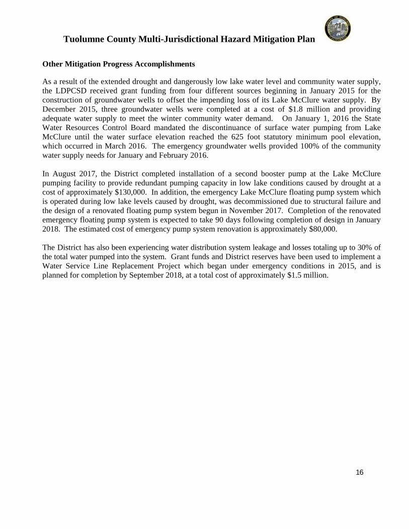
O th er Mitigation Progr ess Acco mp li s h men ts
A s a r e s u l t o f t h e e x t e n d e d d r o u g h t a n d d a n g e r o u s l y l o w l a k e w a t e r l e v e l a n d c o m m u n i t y w a t e r s u p p l y , t h e L D P C S D r e c e i v e d g r a n t f u n d i n g f r o m f o u r d i f f e r e n t s o u r c e s b e g i n n i n g i n J a n u a r y 2 0 1 5 f o r t h e c o n s t r u c t i o n o f g r o u n d w a t e r w e l l s t o o f f s e t t h e i m p e n d i n g l o s s o f i t s L a k e M c C l u r e w a t e r s u p p l y . B y D e c e m b e r 2 0 1 5 , t h r e e g r o u n d w a t e r w e l l s w e r e c o m p l e t e d a t a c o s t o f $ 1 . 8 m i l l i o n a n d p r o v i d i n g a d e q u a t e w a t e r s u p p l y t o m e e t t h e w i n t e r c o m m u n i t y w a t e r d e m a n d . O n J a n u a r y 1 , 2 0 1 6 t h e S t a t e W a t e r R e s o u r c e s C o n t r o l B o a r d m a n d a t e d t h e d i s c o n t i n u a n c e o f s u r f a c e w a t e r p u m p i n g f r o m L a k e M c C l u r e u n t i l t h e w a t e r s u r f a c e e l e v a t i o n r e a c h e d t h e 6 2 5 f o o t s t a t u t o r y m i n i m u m p o o l e l e v a t i o n , w h i c h o c c u r r e d i n M a r c h 2 0 1 6 . T h e e m e r g e n c y g r o u n d w a t e r w e l l s p r o v i d e d 1 0 0 % o f t h e c o m m u n i t y w a t e r s u p p l y n e e d s f o r J a n u a r y a n d F e b r u a r y 2 0 1 6 .
In August 2017, the District completed installation of a second booster pump at the Lake McClurepumping facility to provide redundant pumping capacity in low lake conditions caused by drought at acost of approximately $130,000. In addition, the emergency Lake McClure floating pump system whichis operated during low lake levels caused by drought, was decommissioned due to structural failure andthe design of a renovated floating pump system begun in November 2017. Completion of the renovatedemergency floating pump system is expected to take 90 days following completion of design in January2018. The estimated cost of emergency pump system renovation is approximately $80,000.
The Dist rict has also been experiencing water distribution system leakage and losses totaling up to 30% ofthe total water pumped into the system. Grant funds and District reserves have been used to implement aWater Service Line Replacement Project which began under emergency conditions in 2015, and isplanned for completion by September 2018, at a total cost of approximately $1.5 million.
Tuol umne Co unty Mul ti -Juris dictio na l Ha za rd Mitiga tio n Pl a n
17
C. Goals, Ob jectives an d Mitigation Action s 2018
Goal 1 Promote understanding and support for hazard mitigation
by key stakeholders and the public within TuolumneCounty.
Applies to: All jurisdictions
Objective 1 Educate key stakeholders and the public to increase awareness
of hazards and opportunities for mitigating hazards.
Mitigation Action 1A: Through newsletters, advertisements, speaking engagements
and other public contacts, educate the general public and key
stakeholders on the issues, responsibilities, and current efforts
and successes in the area of disaster preparedness as they
impact each agency.
Mitigation Action 1B: Conduct periodic workshops and promotion of the Emergency Notification Systems available to the public to ensure familiarity of the public to warning applications.
Goal 2 Ensure that future development is protected from natural
disasters.
Applies to: Tuolumne County, City of Sonora, Tuolumne Band of Me-
Wuk Indians, and the Tuolumne Utilities District.
Objective 2Limit new development in hazardous areas, and aspermissible, build to standards that will prevent or reducedamage.
Mitigation Action 2A: Educate the County and City planning staffs, administrative
staffs and elected officials on the importance of keeping
current on trends and developments in disaster preparedness.
Mitigation Action 2B: Encourage planning staffs to attend seminars and lectures on
naturally occurring hazards so that they may better assist the
appropriate governing bodies as they process future
developments.
Tuol umne Co unty Mul ti -Juris dictio na l Ha za rd Mitiga tio n Pl a n
18
Mitigation Action 2C: In order to better protect life and property, continue to develop
a more accurate and comprehensive series of countywide
GIS geology, fire, and flood maps and data sets.
Goal 3 Build and support local capacity and commitment to
minimize the jurisdictions within Tuolumne County’svulnerability to potential hazards.
Applies to: All jurisdictions
Objective 3.1 Improve existing capabilities to manage emergency situations.
Objective 3.2 Enhance the safety of residents, students and staff within the
community and jurisdictions.
Objective 3.3: Enhance the communications between agencies to support emergency response
Mitigation Action 3.1A: In order to ensure that employees are available to assist during a major emergency, develop and adopt a Family Support Plan for all jurisdictions and County agencies.
Mitigation Action 3.1B: Review and when necessary, update the jurisdiction’s Emergency Operations Plans and supporting documents to ensure coordination with the County’s new Emergency Services’ Plan.
Mitigation Action 3.1C: Assist with Public Health Emergency Preparedness to plan and prepare for medical and healthcare impacts which would result from all hazards within the County
Mitigation Action 3.2A: Review the initial planning requirements and research the development of standard operating procedures which would minimize helicopter operations over Sonora Elementary School as they utilize the helistop at Sonora Regional Medical Center
Mitigation Action 3.2B: Support the efforts of the Tuolumne Utilities District to better protect public health by initiating a Watershed Sanitary Survey
Tuol umne Co unty Mul ti -Juris dictio na l Ha za rd Mitiga tio n Pl a n
19
Mitigation Action 3.2C: Assist the County in identifying opportunities for additional evacuation routes within single-access areas
Mitigation Action 3.2D: TUD will study and seek funding to increase the raw water storage or establish a secure conveyance from Lyons Reservoir to ensure service for both domestic consumption and urban fire protection
Mitigation Action 3.2E: Make improvements to wastewater systems by replacing or relining collection pipes so as to reduce sewer overflows and limit inflow and infiltration subsequently reducing the public health threat.
Mitigation Action 3.2F: Develop a program that would, in emergency situations, enable water districts and water companies to share water resources through interconnections
Mitigation Action 3.2G: Develop a program to secure water rights for Tuolumne County
Mitigation Action 3.2 H: Promote a county-wide sewer connection to reduce septic failure impacts and improve water quality.
Mitigation Action 3.2I: Promote land use recommendations that new developments occur adjacent to public water and wastewater facilities.
Mitigation Action 3.3: Build and maintain communications between County
agencies, Special Districts, and the Tuolumne Band of Me-
Wuk Indians to assist in the response to emergencies
Goal 4 Minimize the level of damage and losses to people, existing
and future critical facilities and infrastructure due to flooding.
Applies to: Tuolumne County, City of Sonora, Curtis Creek School District,
Belleview School District
Objective 4 Enhance the ability of community assets, particularly critical
facilities, located in the 100-year floodplain to handle existing
and projected flood levels
Mitigation Action 4A Work to improve localized flood prone areas through a
combination of vegetation management and storm drain

Tuol umne Co unty Mul ti -Juris dictio na l Ha za rd Mitiga tio n Pl a n
20
improvements. (i.e. Sonora, Curtis, Sullivan, and Woods
Creeks)
Mitigation Action 4B: Maintain compliance with the National Flood Insurance
Program (NFIP) requirements.
Mitigation Action 4C: Through the Development Process Review Team, restrict
construction of essential service facilities in the 100-year
flood plain.
Mitigation Action 4D: In order to better protect life and property, record a notice on properties located in flood zones utilizing FIRM maps and notify property owners of said action.
Mitigation Action 4E: Continue to work cooperatively with the state and federal flood related agencies for funding improvements through grant and agency programs.
Mitigation Action 4F: Seek funding sources for and initiate watershed
improvement projects for the County.
Mitigation Action 4G: Study ways to improve drainage to prevent erosion on thesteep slopes of the Curtis Creek campus and seek fundingsources for mitigation.
Mitigation Action 4H: Study ways to improve drainage to prevent erosion on the steep slopes of the Belleview School campus and seek funding sources for mitigation.
Mitigation Action 4I: Work with Belleview School to identify and evaluate opportunities to create additional evacuation routes within the single-access areas in the district.
Goal 5 Minimize the level of damage and losses to people, existing
and future critical facilities and infrastructure due towildland fires.
Applies to: All Jurisdictions
Tuol umne Co unty Mul ti -Juris dictio na l Ha za rd Mitiga tio n Pl a n
21
Objective 5.1 Continue the comprehensive approach to reducing the level of damage
and losses due to wildland fires through vegetation management, code
enforcement, GIS mapping, and planning process.
Objective 5.2 Enhance collaboration amongst all fire agencies and stakeholders.
Mitigation Action 5.1A: In order to assist fire prevention efforts and to better manage large fires
when they occur, continue to improve GIS mapping and tracking efforts
by gathering and maintaining relevant GIS data layers and imagery and
utilizing the best available mapping applications and software.
Mitigation Action 5.1B: Continue to work with the Hwy 108 Fire Safe Council, Yosemite
Foothills FireSafe Council, and SWIFT to initiate fuel thinning and
chipping projects in high priority areas. Collaborate with property owners
and regulatory agencies in order to utilize prescribed fire on private and
state owned lands in the county.
Mitigation Action 5.1C: Work with the Hwy 108 Fire Safe Council, Yosemite Foothills Fire Safe
Council, and SWIFT to update as needed the Community Wildfire
Protection Plans for the County so that they will continue to:
- Assess the fire hazard in the County
- Prioritize treatment areas
- Enhance collaboration amongst all fire agencies and stakeholders
- Streamline environmental review processes
Mitigation Action 5.1D: Develop a wildfire evacuation plan which includes sheltering in place at
Curtis Creek School.
Mitigation Action 5.1E: Work with the Tuolumne Utilities District to improve fire flow, system
reliability and redundancy, and increased water supply in their
responsibility areas.
Mitigation Action 5.1F: Protect water conveyance system by reducing fuels adjacent to wooden
flumes.
Mitigation Action 5.1G: Develop a County Fire Agency GIS layer showing fire water draft
locations.
Mitigation Action 5.1H: W ork wit h the Lake Don Pedro Community Services District t o im prove

Tuol umne Co unty Mul ti -Juris dictio na l Ha za rd Mitiga tio n Pl a n
22
s yst em reliabil i t y and redundan c y, and in c r eased water suppl y in t he ir
responsi bil it y a reas.
Mitigation Action 5.1I: W ork wit h the Lake Don Pedro Community Services District and PG&E
to improve the reliability of the electrical grid in Don Pedro and provide
for emergency backup power supply to be used during power outages at
critical water system facilities.
Mitigation Action 5.2A: Encourage participation of all Fire Agencies in the monthly Fire Chief
Association meetings and support, when possible, efforts by the
Association to improve fire protection and preventions efforts in the
County.
Mitigation Action 5.2B: Encourage participation in cooperative automatic and mutual aid
agreements between Districts, the County and the City of Sonora.
Goal 6 Minimize the level of damage and losses to people, existing
and future critical facilities and infrastructure due togeological events (earthquakes, volcanoes, landslides, and
sinkholes).
Applies to: All jurisdictions
Objective 6 Continue public education efforts so as to better prepare the
citizens of Tuolumne County from the effects of a significant
geological event
Mitigation Action 6A: Working with Cal OES, increase participation in earthquake preparedness activities such as the annual Great California Shake-Out drill
Mitigation Action 6B: Continue to support the work of utility districts in replacing sewer and water lines and portions of the flume that are the most vulnerable to an earthquake or landslide
Goal 7 Limit risk to, and impacts from hazardous materials spills,
intentional discharges, illegal disposals, transportationaccidents, or system failures

Tuol umne Co unty Mul ti -Juris dictio na l Ha za rd Mitiga tio n Pl a n
23
Applies to: All Jurisdictions
Objective 7.1 Continue efforts to manage the use, sale, distribution and
disposal of hazardous materials in Tuolumne County
Objective 7.2 Improve emergency response efforts in the control and clean-up
of accidental spills and releases
Mitigation Action 7.1A: Educate community members on the dangers associated with household hazardous materials including proper storage techniques
Mitigation Action 7.1B: Continue efforts to educate applicable employees on the handling, use, storage and disposal of hazardous materials utilized in the workplace
Mitigation Action 7.2A: In coordination with the Environmental Health Director,
develop procedures to enhance the response to Hazardous
Material Incidents
Goal 8 Minimize the level of damage and losses to people, existing
and future infrastructure, and critical facilities due to
extreme weather
Applies to: All Jurisdictions
Objective 8.1 Continue the comprehensive approach to reducing the level
of damage and losses due to extreme weather and drought
through GIS mapping, planning process, and the removal of
dead and dying trees.
Mitigation Action 8.1A : Analyze and remove hazards that threaten public safety dueto the cascading effects of drought such as dry wells and tree mortality
Mitigation Action 8.1B: Encourage water agencies to conduct water supply evaluations for each public water system to determine the effect of drought on community water supply

Tuol umne Co unty Mul ti -Juris dictio na l Ha za rd Mitiga tio n Pl a n
24
Mitigation Action 8.1C: W ork wit h the Lake Don Pedro Community Services District t o im prove the availability and reliability of Lake McClure pumping capacities at lower water surface elevations
Mitigation Action 8.1D: W ork wit h the Lake Don Pedro Community ServicesDistrict t o increase groundwater supply and/or identify other alternate water sources to be used when drought and related reservoir operational requirements diminish the water supply available from Lake McClure

Tuol umne Co unty Mul ti -Juris dictio na l Ha za rd Mitiga tio n Pl a n
25
D. How Mitigation Goals Ad d ress E xis tin g and New B u ild in gs an d Inf rastru ctu reThe foll owing t ables demonst rate how the pro posed mi ti gati on go als t ake int o account bot h ex isting and new buil din gs and infrastructure.
MIT IGATIONGOAL S
E XIS TING B UIL DINGS AND INFRAS T RUCT URE
El ectrical andP ow er
I nf rastruct ure
Dam s a ndWat er
Managem ent
Com m uni cat i onF acil it i es
Cri ti calRoads & B ri dges
Es s enti alService F acil it i es
(F i re, Law , H os pit al s
Agri c ul turalI nf rastr uct ure
P ubl i cSt ructures
Go a l 1 - Genera lM it ig a tio n: P ro mo teund er sta nd i ng a nd s up p o r t fo r haz ar d miti gatio n b y ke y stake ho ld er s a nd t he p ub lic wi t hi n t he Co unt y o f T uo lu mne.
X X X X X X X
Go a l 2 - Genera l M it ig a tio n: E nsur e tha t fut ur e d evelo p me nt i sp r o tected fr o m na tur ald isa ster s.
X X X X X X X
Go a l 3 - Genera lM it ig a tio n: B uild andsup p o r t lo cal cap acit y a nd co mmi t me nt to mi ni mize the Co unt y o f T uo l u mn e’ s vul ner a b ilit y to p o tential hazar d s.
X X X X X
Go a l 4 - F lo o d: M ini mizethe leve l o f d a ma ge andlo sses to p eo p le, existi ng and fut ur e cr itical facili tiesand i n fr astr uc tur e d ue to
flo o d ing.
X X X X X X X
Tuol umne Co unty Mul ti -Juris dictio na l Ha za rd Mitiga tio n Pl a n
26
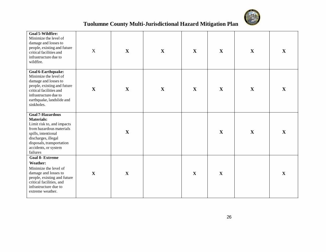
Go a l 5 - Wildf ire:M ini mize t he level o fd a ma ge a nd lo sses to p eo p le, existin g and f ut ur e cr itical facili ties a nd in fr a str uct ur e d ue to wild fir e.
X X X X X X X
Go a l 6 - Ea rt hqua ke:M ini mize t he level o f d a ma ge a nd lo sses to p eo p le, existin g and f ut ur e cr itical facili ties a nd in fr a str uct ur e d ue to ear thq ua ke, land slid e a nd sin k ho les.
X X X X X X X
Go a l 7 - H a za rdo usM a t er ials:Li mit r is k to , and i mp act sfr o m hazar d o us mater ia lssp ills, intent io nal d isc har ge s, ille gal d isp o sals, tr ansp o r tatio n accid ents, o r s yste m fail ur e s
X X X X
Goal 8- Extreme
Weather:
Minimize the level of damage and losses to people, existing and future critical facilities, and infrastructure due to extreme weather.
X X X X X
Tuol umne Co unty Mul ti -Juris dictio na l Ha za rd Mitiga tio n Pl a n
27
MIT IGATIONGOAL S
NEW PROJE CTS /B UIL DINGS AND INFRAS T RUCT URE
Res i dent i alSubdi vis i ons
Vari ous mi xed use proj ect s ( re sident i al
Ag Cl us t ers ( re sident i al, opens pace, and Aguse s)
Com merci al andI ndus tri al
P rojects
Ess en tialS erviceFacilities
Pu b li cS tru ctu res
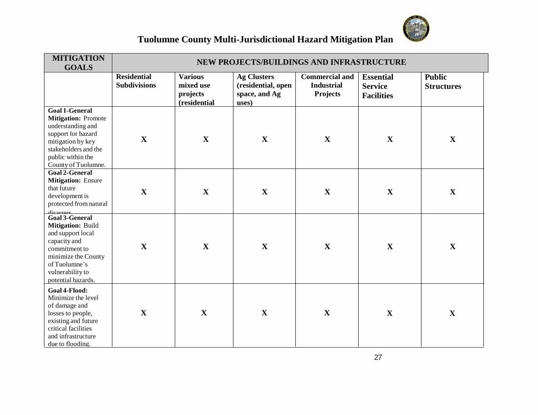
Go a l 1 - Genera lM it ig a tio n: P ro mo teund er sta nd i ng a ndsup p o r t fo r haz ar dmiti gatio n b y ke y stake ho ld er s a nd the p ub lic wi thi n t he Co u nt y o f T uo lu mne.
X X X X X X
Go a l 2 - Genera lM it ig a tio n: E nsur e that fut ur e d eve lo p me nt i s p r o tected fr o m na tur al
d isa ster s.
X X X X X X
Go a l 3 - Genera l M it ig a tio n: B uildand s up p o r t lo calcap ac it y a nd co mmi t me nt tomi ni mize the Co u nt yo f T uo l u mne ’s vul ner a b ilit y to p o te ntial hazar d s.
X X X X X X
Go a l 4 - F lo o d:M ini mize t he level o f d a ma ge a nd lo sses to p eo p le, existin g and fut ur e cr itical facilit ies and in fr a str uct ur e d ue to flo o d ing.
X X X X X X

Tuol umne Co unty Mul ti -Juris dictio na l Ha za rd Mitiga tio n Pl a n
28
Go a l 5 - Wildf ire:M ini mize t he level o fd a ma ge a nd lo sses to p eo p le, existin g and fut ur e cr itical facilit ies and in fr a str uct ur e d ue to wild fir e.
X X X X X X
Go a l 6 - Ea rt hqua ke:M ini mize t he level o f d a ma ge a nd lo sses to p eo p le, existin g and fut ur e cr itical facilit ies and in fr a str uct ur e d ue to ear thq ua ke, land slid e and sin k ho les.
X X X X X X
Go a l 7 - H a za rdo usM a t er ials:Li mit r is k to , and i mp acts fr o mhazar d o us ma ter ials sp ills, intent io nald isc har ge s, ille gal d isp o sals,tr ansp o r tatio naccid ents, o r s yste m fail ur e s
X X X X X X
Goal 8- Extreme
Weather:
Minimize the level of damage and losses to people, existing and future critical facilities, and infrastructure due to extreme weather.
X X X X

Tuol umne Co unty Mul ti -Juris dictional Ha za rd Mitiga tio n Pl a n
_29
VI. MIT IGATION ACTION IMPL E ME NT ATION
A. DMA 2000 Req ui remen ts:
DMA Req ui remen t The plan maint enan ce process sh all in clude a section describi ng th e§201.6(c)(4 )(i): method and schedule o f moni to ring, evaluatin g, and updati ng the
mitigati on pl an wit hin a five- ye a r c ycl e.
DMA Req ui remen t The plan shall in clude a process b y which lo cal governments§201.6(c)(4 )(ii): incorporate th e requi rements of the mi ti gati on pl an int o oth er
planning mechanism s su ch as comprehensive or c apit al i mp rovementplans, when approp riate.
DMA Req ui remen t The mitigati on st rateg y s ecti on shall in clude an ac ti on pl an§201.6(c)(3 )(iii): describi n g how the acti ons identi fied in s ecti on (c)(3)(ii) will be
prioritiz ed, im pl em ented, and admi nist ered b y the local jurisdi cti on. P rioritiz ati on shall include a speci al emphasis on the ex tent t o which benefit s are max imi z ed accordin g to a cost b enefit review of th e proposed projects and their associated costs.
DMA Req ui remen t For mul ti -jurisdi ction al plans, there must be id entifiable acti on it ems§201.6(c)(3 )(iv) specific to t he jurisdi cti on requesti n g FEMA app r oval or credit of the
plan.
B . Prioriti zation of Mitigation Action s
The Miti gati on acti ons were prioritiz ed using a s ystem which is outli ned below. This s ystemfactored in the foll owing components: 1) P ro babil i t y of Occu rren ce 2) Ef fectiven ess ofMiti gati on Acti ons, 3 )P racticalit y of mitigati on acti on for th e juris dicti on based on theS TAP LE+E criteri a of S ocial, Techni cal, Admi nist rative, P oli ti cal, Le gal, Economi c andEnvironmental components. This gave rise to th e developm ent of an ove rall relative risk v aluethat result ed in ratings o f H IGH, ME D IU M and LOW for each of the mi ti gati on acti ons. Theresult ant prioritiz ati on was presented to criteria k e y stak eholders and len gth y dis cussi ons wereheld to ensure that the result s were ind eed applicable to the priorities and capabil iti es of th ejurisdi cti ons s erved.

Tuol umne Co unty Mul ti -Juris dictional Ha za rd Mitiga tio n Pl a n
_30
S amp le Mitigation Action Prioriti zation Work sh eetMiti gati onActi on
P robabil it y ofAssociatedThreat Occurrenc e Low=1Med.=2High=3
Effectiven ess of Miti gati onActi onMinim al=1Moderate=2High=3
P racticalit y(based onS TAP LE+E criteria) Low=1Medium =2High=3
R elati ve Risk(P roduct of RiskCompon ents)
1.A 3 2 3 18
In assessin g and ev aluati ng each st rat eg y, the foll owing factors were consi dered:
The benefit just i fied the cost
The availabilit y o f finan c ial resources
The availabilit y o f staff r esources
Imp act on C oun t y d epart ment functi ons
S trategies refl ect t he goal s and objectives
C. Action Plan
Once th e MJ HMP has received formal adopti on b y th e Bo ard of S uper viso rs and the variousgov ernin g bodies the foll o wing acti on plan, agre e d upon b y Haz ard Miti gati on P lanning Group,will be used to ensure the P lan is im pl emented and rem ains an acti ve and relev ant document.Actual i mpl ementati on ma y b e dep endent upon fu nding av ailabil i t y.
Tuol umne Co unty Mul ti -Juris dictional Ha za rd Mitiga tio n Pl a n
_31
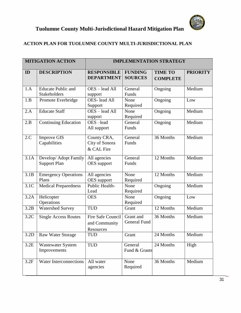
ACTION PL AN FOR T UOL UMNE COUNT Y MUL T I-JURIS DICT IONAL PL AN
MIT IGAT ION ACT ION IMPL E ME NT AT ION S T RAT E GY
ID DE S CRIPT ION RE S PONS IB L E DE PART ME NT
FU NDIN GS OURCE S
TIME TO
COMPLETE
PRIORIT Y
1.A Educate P ublic and S takeholders
OES – lead All support
Gener alFunds
Ongoin g Medium
1.B Promote Everbridge OES- lead All Support
None Required
Ongoing Low
2.A Educate S taff OES – lead All support
NoneR equired
Ongoin g Medium
2.B C ontinuing Education OES –leadAll support
Gener alFunds
Ongoin g Medium
2.C Improv e G ISC apabilities
C ount y C R A,C it y o f S onora
& C A L Fire
Gener alFunds
36 Months Medium
3.1A Develop/ Adopt Famil yS upport P lan
All agenciesOES support
Gener alFunds
12 Months Medium
3.1B Emer genc y Operations P lans
All agenciesOES support
NoneR equired
12 Months Medium
3.1C Medical Preparedness Public Health-Lead
All Support
None Required
Ongoing Medium
3.2A HelicopterOperations
OES NoneR equired
Ongoing Low
3.2B W a t e r s h e d S u r v e y TUD Grant 12 Months Medium
3.2C S i n g l e A c c e s s R o u t e s Fire Safe Council
and Community
Resources
Grant and General Fund
36 Months Medium
3.2D R aw W ater S tora ge TUD Grant 24 Months Medium
3.2E W astewater S ystemImprov ements
TUD Gener alFund & Grants
24 Months High
3.2F W a t e r I n t e r c o n n e c t i o n s All water agencies
None Required
36 Months Medium
Tuol umne Co unty Mul ti -Juris dictional Ha za rd Mitiga tio n Pl a n
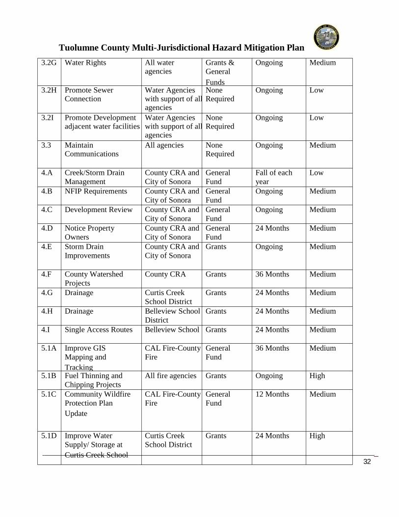
_32
3.2G W ater R ights All wateragencies
Grants &Gener al
Funds
Ongoin g Medium
3.2H P r o m o t e S e w e r C o n n e c t i o n
Water Agencies with support of allagencies
None Required
Ongoing Low
3.2I P r o m o t e D e v e l o p m e n t a d j a c e n t w a t e r f a c i l i t i e s
Water Agencies with support of allagencies
None Required
Ongoing Low
3.3 M a i n t a i n C o m m u n i c a t i o n s
All agencies None Required
Ongoin g Medium
4.A C reek/S torm DrainMana gement
C ount y C R A andC it y o f S onora
Gener alFund
Fall of e achye a r
Low
4.B NF IP R equirem ents C ount y C R A andC it y o f S onora
Gener alFund
Ongoin g Medium
4.C Development R eview C ount y C R A andC it y o f S onora
Gener alFund
Ongoin g Medium
4.D Notice P ropert yOwners
C ount y C R A andC it y o f S onora
Gener alFund
24 Months Medium
4.E S torm DrainImprov ements
C ount y C R A andC it y o f S onora
Grants Ongoin g Medium
4.F C ount y W atershedP r o j e c t s
C ount y C R A Grants 36 Months Medium
4. G Draina ge C urtis C reekS chool District
Grants 24 Months Medium
4.H Draina ge Belleview S choolDistrict
Grants 24 Months Medium
4.I Single Access Routes Belleview School Grants 24 Months Medium
5.1A Improv e G ISMapping and
Trackin g
C A L Fire-C ount yFire
Gener alFund
36 Months Medium
5.1B Fuel Thinning andC hipping P rojects
All fire a gen cies Grants Ongoin g High
5.1C C ommunit y W ildfireP rotection P lan
Update
C A L Fire-C ount yFire
Gener alFund
12 Months Medium
5.1D Improv e W aterS uppl y/ S tora ge at
C urtis C reek S chool
C urtis C reekS chool District
Grants 24 Months High

Tuol umne Co unty Mul ti -Juris dictional Ha za rd Mitiga tio n Pl a n
_33
5.1E Evacuation P lans forC urtis C reek
DistrictS uperintendent with fire a gen cies supporting
NoneR equired
12 Months High
5.1F W ater S uppl y/ Fir eFlow
TUD, withfire a gencies supporting
Gener alFunds and
Grants
36 Months High
5.1G P rotect Flumes TUD, with fireagencies supporting
Gener alFunds and
Grants
Ongoin g Medium
5.1H C o u n t y F i r e G I S L a y e r
County GIS- LeadOES- Support
General Funds 36 Months Low
5.1I I n c r e a s e W a t e r S u p p l y f o r L a k e D o n P e d r o C S D
Lake Don Pedro CSD- LeadOES-Support
Gener alFunds and
Grants
36 Months Medium
5.1J I n c r e a s e A l t e r n a t e P o w e r S o u r c e f o r L a k e D o n P e d r o
Lake Don Pedro CSD- LeadOES-Support
Gener alFunds and
Grants
24 Months Medium
5.2A Fire C hiefsAssociation
All fire a gen cies NoneR equired
Ongoin g Medium
5.2B Mutual/Auto Aid All fire a gen cies NoneR equired
Ongoin g Medium
6.A EarthquakeP reparedn ess
Ex ercises
OES – leadAll support
NoneR equired
Fall of Ea chYear
Medium
6.B R eplace Vulne rableW ater/S ewer Lines
TUD Gener alFund
24 Months Medium
7.1A Educate C ommunit yon Haz ardous
Materials
OES – leadAll support
NoneR equired
Ongoin g Medium
7.1B Educate S taff onHaz ardous Materi als
OES – leadAll support
NoneR equired
Ongoin g Medium
Tuol umne Co unty Mul ti -Juris dictional Ha za rd Mitiga tio n Pl a n
_34
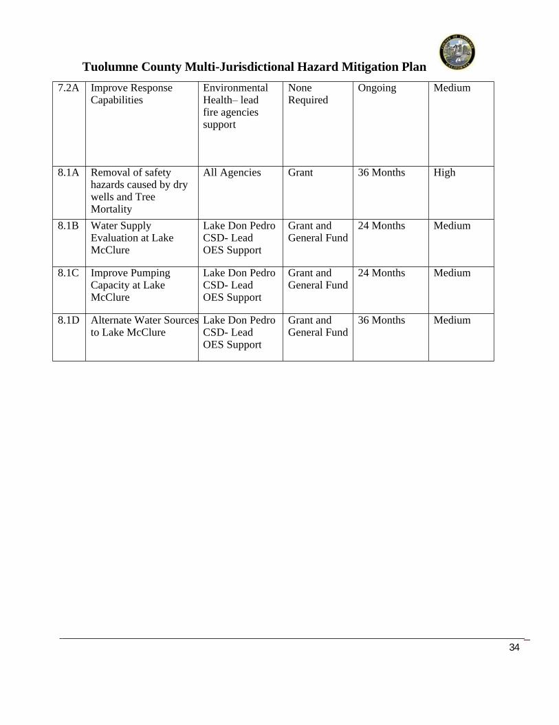
7.2A Improv e R esponseC apabilities
Environmental Health– leadfire a gencies support
NoneR equired
Ongoing Medium
8.1A Removal of safety hazards caused by dry wells and Tree Mortality
A l l A g e n c i e s Grant 36 Months High
8.1B Water Supply Evaluation at Lake McClure
L a k e D o n P e d r o C S D - L e a d O E S S u p p o r t
Grant and General Fund
24 Months Medium
8.1C Improve Pumping Capacity at Lake McClure
L a k e D o n P e d r o C S D - L e a d O E S S u p p o r t
Grant and General Fund
24 Months Medium
8.1D Alternate Water Sourcesto Lake McClure
L a k e D o n P e d r o C S D - L e a d O E S S u p p o r t
Grant and General Fund
36 Months Medium

Tuol umne Co unty Mul ti -Juris dictional Ha za rd Mitiga tio n Pl a n
_35
D. I mp le men tation Th rough Exis tin g Plan s an d Progra msTuolum ne Count y cu rr entl y uses compreh ensi ve land use planning, capit al improvementsplanning, and buil di n g c o des to guide and control developm ent wit hin the Coun t y. This MJ HMPwill be provided to those responsi ble for the Coun t y’s Gen eral P lan development mechanisms toensure that consist enc y i s maint ained. The same holds true when ever su bst anti ve chan ges aremade.
Miti gati on Acti ons have been assign ed to specif ic jurisdi cti ons. These indivi du al acti ons willfall under the gen eral a dmi nist rati ve oversight of the local gov ernin g bod y. S hould technicalex perti se not be available in these agencies, t he Count y Offi ce of E mergenc y S ervi ces iscomm it t ed to, when possi bl e, coordinati ng the resources of the C ount y to assi st wit him pl ementation of the miti gati on acti ons.
The gen eral admi nist rative oversi ght of this MJ HMP rests with the Tuolumne Count y Offic e ofEmergen c y S ervices.
E . Con tinu ed Pu b li c In volv emen t Tuolum ne Count y and t h e Dist rict understand the im portance of invol vi n g the publi c in t he ongoin g Haz ard Miti gati on P l an review and upd ating process. R esultantl y, the foll owingacti ons wil l be taken:
A cop y o f the M J HMP wil l be post ed on the Count y websit e Hard copies o f the P lan wil l be available at t he C ount y Office o f Emergen c y S ervices
the Count y Lib rar y, and on the Lake Don Pedro CSD website.
F. Plan Mon i torin g, Evalua tin g and Up d atin g
DMA Req ui remen t A local j urisdi ction m ust revi ew and revise its pl an to reflect chan ges in§201.6(d )(3): d evelopm ent, pro gress i n lo cal m it i gati on efforts, and chan ges in
p riorities, and resubmi t i f for approv al wit hin 5 ye ars in o rder to continue to be eligibl e for mitigati on proj ect grant fundin g.
In ord er to conti nue to be an effecti ve represent a ti on of each jurisdicti on’s overall strateg yfor reducin g its risks from natural haz ards, the mitigati on plan must reflect currentcondit ions. Monito ring and evaluati ng the plan w ill occur annuall y to make certain that thegoals and objectives for the Count y and participat ing jurisdi cti ons are cu rr ent and mitigati onacti vit i es are bein g carrie d out.
To ensure that regular re view and upd ate of thi s Multi -J urisdicti onal Hazard Miti gati on Plantakes place, the Coun t y Office o f Emer genc y S e rvices will comm uni cate with the MJ HMPP lanning Group memb ers annuall y to see if their plan components are up-to-date and meetcurrent realities.
Tuol umne Co unty Mul ti -Juris dictional Ha za rd Mitiga tio n Pl a n
_36
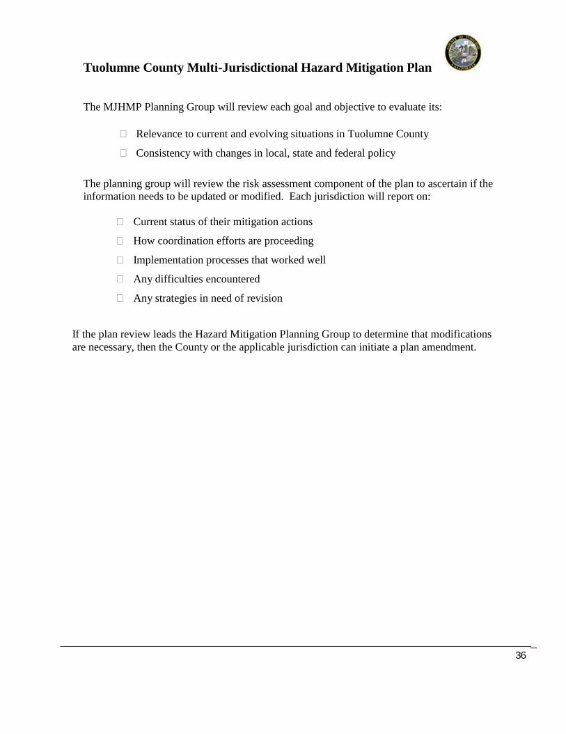
The MJ HMP Planning Group will review each go al and objecti ve to ev aluate it s:
R elevance to current and evolvi ng sit u ati ons in Tuolum ne Count y
Consist en c y wit h chan ge s in l ocal, st ate and fed eral pol i c y
The planning group will review the risk assessment component of the plan to ascertain i f the informati on needs to be updated or modi fied. Each jurisdi cti on will report on:
C urrent st atus of their miti gati on acti ons
How coordin ati on efforts are pro ceeding
Impl ement ati on process es th at worked well
An y difficult i es encounte red
An y strat egies in n eed o f revisi on
If th e plan review leads the Haz ard Miti gati on P l anning Group to d etermine that m odi fications are necessar y, then the C ount y or the appli cable ju risdi cti on can init i ate a plan amendment.

Tuol umne Co unty Mul ti -Juris dictional Ha za rd Mitiga tio n Pl a n
_37
Acron y ms
Acron y m Def in i tion
C GS C alifornia Geolo gical S urve y
C al EP A C alifornia Environment al P rotecti on Agen c y
C altrans C alifornia Department of Transportati on
C A L Fire C alifornia Department of Forestr y and Fi re P rotect ion
C DF C alifornia Department of Forestr y and Fi re P rotect ion
C DHS C alifornia Department of Healt h S ervices
C FR Code of Fed eral R egul ati ons
C GS C alifornia Geolo gical S urve y
C IS N C alifornia Int e grated S ei smi c Network
CS S C C alifornia S eism ic S afety Comm iss ion
DFG S tate Department of Fish and Game
DHS Department of Homeland S ecurit y
DW R Department of W ater R es ources
FEMA Fed eral Emergen c y M an agement A gen c y
F IR M Flood Insuran ce R ate M a p
FMA Flood Mit i gati on Assi st ance
FMP Floodpl ain M ana gem ent P l an
FR AP Fire and R esource Asses sment P rogram
G IS Geo graphic Inform ati on S ystem
HMGP Haz ard Miti gati on Grant P rogram
LHMP Lo cal Haz ard Mit i gati on P lan
NF IP Nati onal Flood Insu rance P rogram
NOAA Nati onal Oceanic and Atmospheric Admi nist rati on
NP S Nati onal P ark S ervices
OES Governor’s Office of Em ergen c y S ervices
S EMS S tandardiz ed Emergenc y Management S ystem
S FHA S pecial Flood Haz ard Area
US DA U.S . Department of Agri cult ure
US GS U.S . Geological S urve y
Tuolumne County Multi-Jurisdictional Hazard Mitigation Plan
Top Related