Networks of Complete Streets - Smart Growth …...Networks of Complete Streets In many places built...
3
National Complete Streets Coalition 1707 L St. NW Suite 250 Washington, DC 20036 202-207-3355 IMPLEMENTING COMPLETE STREETS Networks of Complete Streets In many places built since the 1950s, roadway design usually means a system of widely spaced, large arterials fed by smaller roadways that rarely connect with each other. This system concentrates motorized traffic on a limited number of large roads, which causes longer, indirect trips and limits opportunities for alternate routes. Such a network makes it difficult for people who might walk, bike, or take public transportation because the indirect routes lengthen their trips and force them onto roads that are usually not designed for their safety or comfort. Public transportation also has a difficult time serving isolated neighborhoods with only one or two entry or exit points. So, people end up driving, even for very short trips. Communities that have adopted Complete Streets policies sometimes struggle with retrofitting multi-lane arterials that must carry heavy automobile traffic but are also the only choice for bicycling, walking, and public transportation. Many realize they must look for opportunities to increase street connectivity in order to give people choices when traveling between home, medical offices, schools, shops, and workplaces. Conventional street networks (left) create longer trips and often deny choice. A network of Complete Streets (right) offers flexibility. Image: Kimley-Horn and Associates, Inc. and Digital Media Productions Complete Streets are connected streets Well-designed, connected Complete Streets make travel more efficient by providing choice not only in modes, but also in routes. Pedestrians and public transportation riders are especially motivated to find direct routes to their destination or their transit stop, and prefer lower-traffic streets. This is much easier to do when the street network is a connected grid of relatively short blocks. Instead of trying to make each street perfect for every traveler, communities can create an interwoven array of streets that emphasize different modes and provide quality accessibility for everyone. Some streets may emphasize vehicles or trucks, while others emphasize pedestrians or public transportation. In more industrial areas, some streets will emphasize access for freight vehicles Charlotte, North Carolina defines its street network along a continuum from most
Transcript of Networks of Complete Streets - Smart Growth …...Networks of Complete Streets In many places built...
National Complete Streets Coalition � 1707 L St. NW Suite 250 � Washington, DC 20036 � 202-207-3355
IMPLEMENTING COMPLETE STREETS
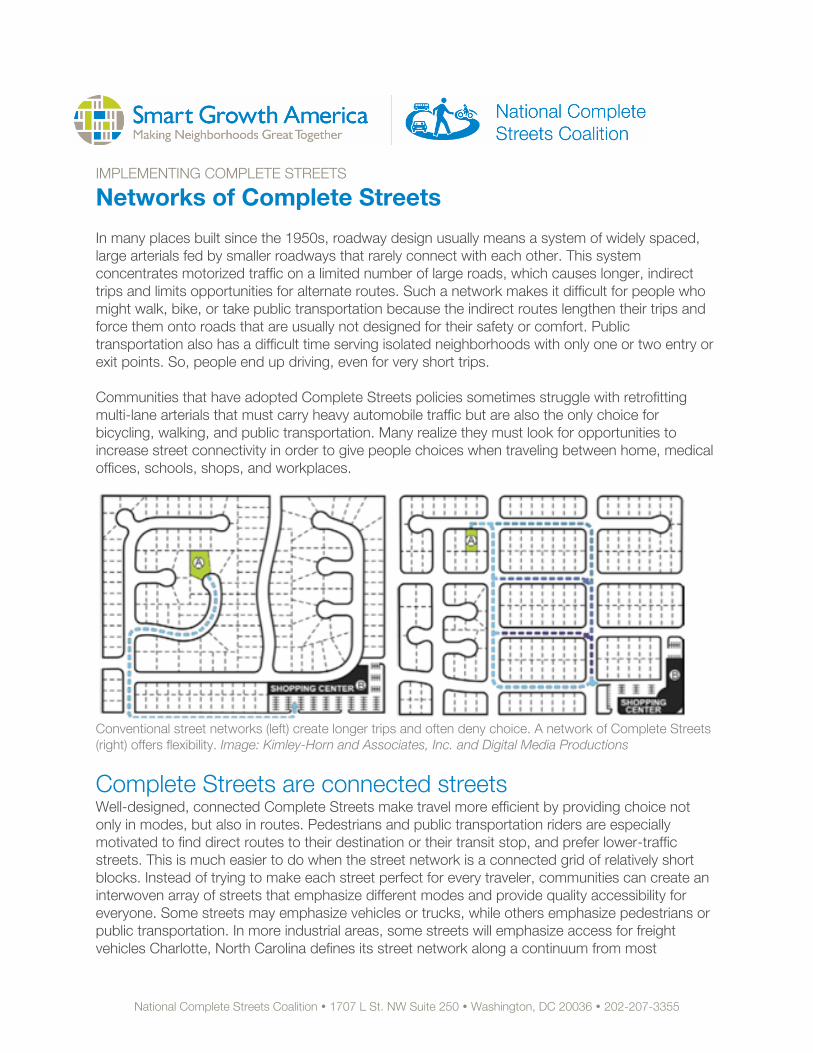
Networks of Complete Streets In many places built since the 1950s, roadway design usually means a system of widely spaced, large arterials fed by smaller roadways that rarely connect with each other. This system concentrates motorized traffic on a limited number of large roads, which causes longer, indirect trips and limits opportunities for alternate routes. Such a network makes it difficult for people who might walk, bike, or take public transportation because the indirect routes lengthen their trips and force them onto roads that are usually not designed for their safety or comfort. Public transportation also has a difficult time serving isolated neighborhoods with only one or two entry or exit points. So, people end up driving, even for very short trips. Communities that have adopted Complete Streets policies sometimes struggle with retrofitting multi-lane arterials that must carry heavy automobile traffic but are also the only choice for bicycling, walking, and public transportation. Many realize they must look for opportunities to increase street connectivity in order to give people choices when traveling between home, medical offices, schools, shops, and workplaces.
Conventional street networks (left) create longer trips and often deny choice. A network of Complete Streets (right) offers flexibility. Image: Kimley-Horn and Associates, Inc. and Digital Media Productions
Complete Streets are connected streets Well-designed, connected Complete Streets make travel more efficient by providing choice not only in modes, but also in routes. Pedestrians and public transportation riders are especially motivated to find direct routes to their destination or their transit stop, and prefer lower-traffic streets. This is much easier to do when the street network is a connected grid of relatively short blocks. Instead of trying to make each street perfect for every traveler, communities can create an interwoven array of streets that emphasize different modes and provide quality accessibility for everyone. Some streets may emphasize vehicles or trucks, while others emphasize pedestrians or public transportation. In more industrial areas, some streets will emphasize access for freight vehicles Charlotte, North Carolina defines its street network along a continuum from most
National Complete Streets Coalition � 1707 L St. NW Suite 250 � Washington, DC 20036 � 202-207-3355
pedestrian-oriented to most auto-oriented, referring both to the design of the street and to the adjacent land uses. Each street type emphasizes different mixes of modes, but is designed with all potential travelers in mind. In a complete network, short, local trips can be taken without burdening the arterial systems with more cars. Roads in sprawling communities see up to 75 percent more travel demand on those arterials than similar arterials in connected networks.1 People with a complete, connected network of options may opt to reach their destination entirely without driving on arterials, or will instead walk, bike, or take public transportation. One study found that single-family households located in a network of Complete Streets made a similar number of total trips as those in an incomplete network, but made significantly fewer by car, instead opting to walk.2 Connected streets can reduce traffic congestion by dispersing traffic and offering travel options. Networks of connected Complete Streets can carry as many travelers as conventional sprawling roadway design, but do not rely on a sparse network of major arterials.3 Parallel routes within connected networks maintain this high corridor capacity, while providing different routes to destinations for convenience, variety, or to avoid construction. These choices help all users of the system by reducing travel delays associated with reliance on very few routes.
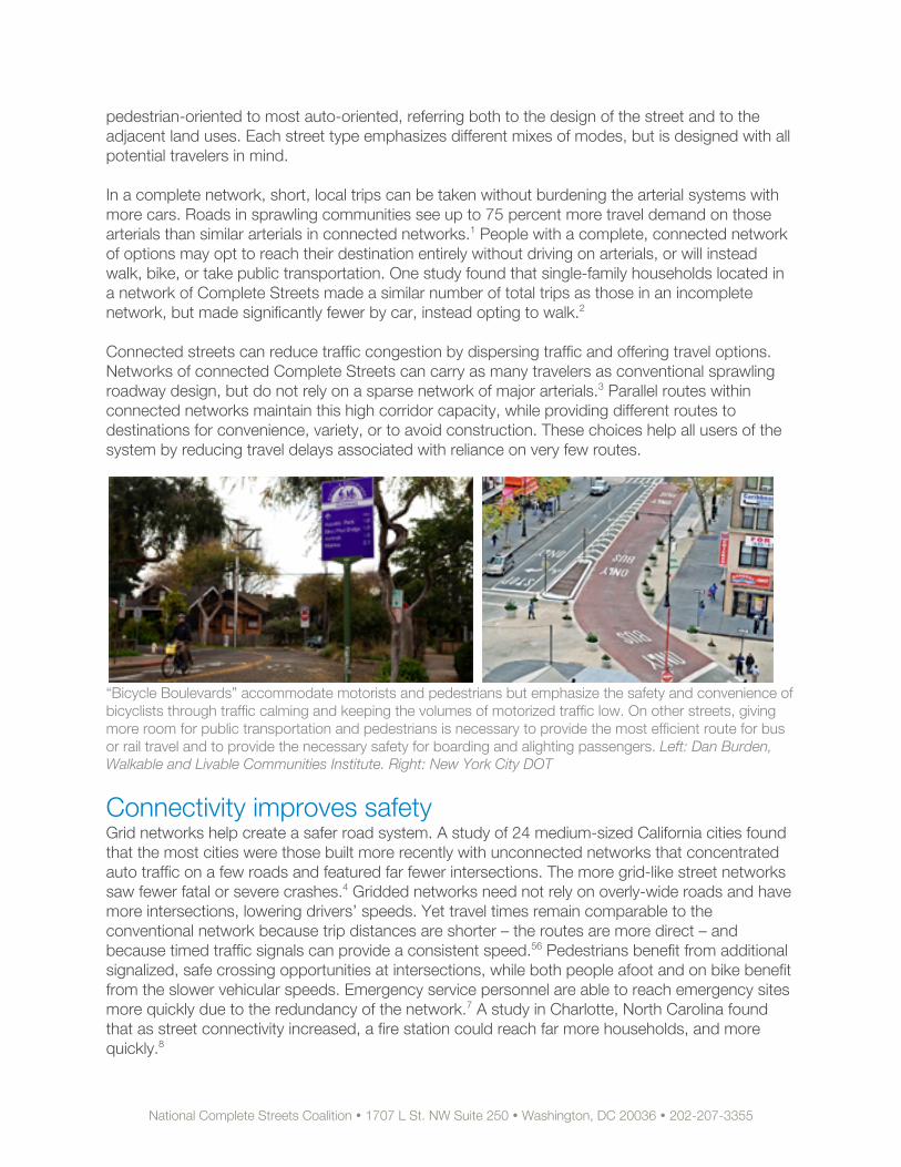
“Bicycle Boulevards” accommodate motorists and pedestrians but emphasize the safety and convenience of bicyclists through traffic calming and keeping the volumes of motorized traffic low. On other streets, giving more room for public transportation and pedestrians is necessary to provide the most efficient route for bus or rail travel and to provide the necessary safety for boarding and alighting passengers. Left: Dan Burden, Walkable and Livable Communities Institute. Right: New York City DOT
Connectivity improves safety Grid networks help create a safer road system. A study of 24 medium-sized California cities found that the most cities were those built more recently with unconnected networks that concentrated auto traffic on a few roads and featured far fewer intersections. The more grid-like street networks saw fewer fatal or severe crashes.4 Gridded networks need not rely on overly-wide roads and have more intersections, lowering drivers’ speeds. Yet travel times remain comparable to the conventional network because trip distances are shorter – the routes are more direct – and because timed traffic signals can provide a consistent speed.56 Pedestrians benefit from additional signalized, safe crossing opportunities at intersections, while both people afoot and on bike benefit from the slower vehicular speeds. Emergency service personnel are able to reach emergency sites more quickly due to the redundancy of the network.7 A study in Charlotte, North Carolina found that as street connectivity increased, a fire station could reach far more households, and more quickly.8
National Complete Streets Coalition � 1707 L St. NW Suite 250 � Washington, DC 20036 � 202-207-3355
Right-sized blocks A network of Complete Streets works best if block size is reduced. Short blocks are important to people on bikes or on foot because they reduce the total distance traveled and provide direct access to properties. A smaller block structure also allows land use to evolve and adapt over time, providing development flexibility. After updating its City Code to achieve Complete Streets, North Myrtle Beach, South Carolina now requires most blocks to be human-scaled, between 300 and 400 feet long. For transit providers, a community of Complete Streets with shorter blocks is easier to serve. Most agencies look for a ½ mile spacing between routes, which is more easily achieved with a grid system, as is easy travel in any direction.9
Increase connectivity with Complete Streets Some places with Complete Streets policies have included provisions specifically to increase connectivity. For example, Virginia's Complete Streets policy was augmented by a new policy to end maintenance support for new streets that end in cul-de-sacs. Other communities have required new developments to connect into the existing grid in multiple locations. Some built-out communities with a sprawling road system have looked for opportunities to create more non-motorized connections by installing paths that connect cul-de-sacs and other disconnected streets to nearby roads. Even when roads are connected, there may still be a need for connected grids of walking and bicycling networks. The incorporation of Complete Streets into all of Seattle, Washington’s plans helps to identify gaps in the network for different modes and prioritizes investment to create complete networks for all modes. Reaching connectivity through Complete Streets policies directs transportation funding to create complete networks for all modes and helps support the livable communities that people want.
Learn more at www.smartgrowthamerica.org/completestreets. 1 Proft, J. & Condon, P. (2001). Transportation and Community Design: The effects of Land Use and Street Pattern on Travel Behavior. James Taylor Chair in Landscape and Liveable Environments. University of British Columbia 2 Khattak, A. & Rodriguez, D. (2005). “Travel behavior in neo-traditional neighborhood developments: A case study in USA.” Transportation Research Part A: Policy and Practice, 39 (6). pp. 481-500. 3 Proft, J. & Condon, P. (2001). 4 Urban Design International. (2010, April). Street network types and road safety: A study of 24 California cities. Marshall, W & Garrick, N. 5 Proft, J. & Condon, J. (2001). 6 Institute for Transportation Engineers. (2010). Designing Walkable Urban Thoroughfares: A Context Sensitive Approach: An ITE Recommended Practice. 7 Trowbridge, M., Gurka, M., & O’Connor, R. (2009). “Urban Sprawl and Delayed Ambulance Arrival in the U.S.” American Journal of Preventative Medicine, 37(5). 8 Pleasant, D. (2008). “Sustainable Street Network: Emergency Responder Perspective.” Presentation to the CNU Transportation Conference in Charlotte, North Carolina. 9 Kilcoyne, R. (2007). Completing the Streets for Transit: Complete Streets Checklist. Transportation Planning Capacity Building Program, Peer Exchange Report, Nashville, TN.